Introduction
During active threats, every second counts—but blanket alerts to entire organizations create confusion, desensitization, and operational noise. Geo-targeted crisis alerting sends emergency notifications only to people within specific geographic boundaries, ensuring affected populations receive critical information without overwhelming unaffected areas.
This article is written for emergency management agencies, public safety officials, government bodies, healthcare facilities, and corporate crisis managers.
While "geo-targeting" appears frequently in mass notification marketing, the actual technical process, strategic implementation, and integration with incident management systems remain poorly understood at the operational level.
Emergency managers frequently ask: How does the technology work? What location data is required? When should I use geo-targeting versus organization-wide alerts?
This article covers:
- How geo-targeted alerting works technically
- Advanced strategies beyond basic location alerts
- Factors affecting accuracy and effectiveness
- When to choose geo-targeting versus organization-wide notifications
Understanding these operational realities helps emergency managers make informed decisions during high-stakes crisis events.
Key Takeaways
- Sends emergency alerts only to populations within defined impact zones, preventing alert fatigue
- Uses GPS, cell tower data, and GIS integration to pinpoint recipients in affected areas
- Enables dynamic boundary adjustment, layered alert zones, and integration with FEMA-compliant systems
- Requires accurate location data, proper infrastructure, and compliance with IPAWS and NIMS standards
What Is Geo-Targeted Crisis Alerting?
Geo-targeted crisis alerting sends emergency notifications exclusively to individuals within specific geographic areas affected by a crisis event. Location-based technologies filter recipients, ensuring alerts reach only relevant populations.
Key benefits include:
- Reduces notification fatigue by limiting alerts to affected areas
- Optimizes emergency response resources through precise targeting
- Maintains public trust by avoiding unnecessary panic in unaffected zones
- Ensures regulatory compliance with accuracy standards
Geo-targeting differs fundamentally from mass notification, which sends alerts to everyone in a database regardless of location. It also differs from broadcast alerts, which reach all devices in a cell tower range without recipient filtering.
The precision of geo-targeting makes it the preferred method for modern emergency management. This is particularly important as regulatory standards like IPAWS and FEMA guidelines increasingly demand notification accuracy.
Why Geo-Targeting Is Critical in Crisis Management
Emergency managers adopt geo-targeting to solve a growing problem: alert fatigue. When people receive too many irrelevant emergency notifications, they begin ignoring all alerts, including critical ones that affect them.
Research shows that approximately 30% of alert recipients receive messages irrelevant to their location. This leads to a documented 15% drop-off in public compliance for subsequent warnings.
What geo-targeting addresses:
- Precision in reaching affected populations — ensuring warnings reach only those at risk
- Resource optimization — focusing response efforts where they're needed most
- Reduced confusion — providing location-specific instructions rather than generic warnings
- FEMA NIMS compliance — meeting federal principles of scalable, targeted communication
Without geo-targeting, emergency communications fail in predictable ways:
Common Failures Without Location Targeting
- Entire cities receive evacuation orders when only two neighborhoods are affected
- Organizations overwhelm unaffected employees with irrelevant crisis updates
- Emergency call centers become flooded with inquiries from people outside impact zones
- Public trust erodes when alerts lack relevance
Geo-targeting is now considered best practice by FEMA, required for IPAWS integration, and increasingly mandated by regulatory bodies for organizations managing critical infrastructure.
The FCC now requires that Wireless Emergency Alerts achieve 100% target area coverage with no more than 0.1-mile overshoot. This regulatory shift moves the industry from "best effort" to precision-driven accountability.
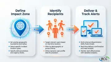
How Geo-Targeted Crisis Alerting Works
Geo-targeted alerting begins with defining a geographic impact zone—the area affected by the crisis. The system then uses location technologies to identify which individuals are within that zone. It filters the notification database to include only those recipients and delivers alerts through appropriate channels while logging all actions for accountability.
Core process components:
- Incident location data — address, coordinates, or mapped area defining the crisis zone
- Boundary definition — radius, polygon, or administrative boundary like zip code
- Recipient database with location information — GPS coordinates, registered addresses, or real-time device location
- Alert content with location-specific instructions — tailored messages for different zones
The system compares recipient locations against the defined impact zone boundaries using geospatial algorithms, creates a filtered list of recipients within the zone, and triggers multi-channel alert delivery (SMS, voice, email, mobile app push notifications) to only those individuals.
Once alerts are configured, emergency managers maintain full control over the response:
- Adjust boundaries in real-time as situations evolve
- Layer multiple alert zones with different severity levels
- Set alert parameters (immediate vs. scheduled, acknowledgment required, repeat intervals)
- Integrate with GIS mapping systems for visual confirmation
This flexibility ensures that as wildfires spread, floods rise, or chemical plumes shift, the alert zones expand or contract accordingly.
Step 1: Define the Geographic Impact Zone
Emergency managers use incident data—fire perimeter, flood zone, hazmat spill radius, evacuation order boundaries—to define the geographic area requiring notification. This can be done by drawing polygons on a map interface, setting radius distances from a point, or selecting administrative boundaries like zip codes, census tracts, or neighborhoods.
The National Weather Service has transitioned to "Storm-Based Warnings" using polygons rather than county-wide alerts, reducing the warned area by approximately 70% compared to county-based warnings and significantly reducing false alarm rates for the public.
Step 2: Identify Recipients Within the Zone
The alerting system uses location technologies to determine which individuals in the notification database are currently within or associated with the defined impact zone:
- GPS coordinates from mobile devices — providing accuracy to within 10-50 meters in open sky conditions
- Registered home/work addresses — matching database addresses against the defined boundary
- Cell tower triangulation data — locating devices based on connection to nearby towers (100 meters to several miles accuracy)
- IP geolocation — identifying approximate locations based on internet connection
WEA 3.0 includes device-based geo-fencing, where the alert message includes the coordinates of the target polygon and the mobile device itself uses its internal location services to determine if it's inside the polygon. If the device is outside, it blocks the alert even if the cell tower broadcast the message.
Step 3: Deliver Targeted Alerts and Track Response
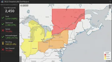
The system sends alerts through multiple channels—SMS, voice calls, email, mobile app notifications—to only the filtered recipient list. The system logs all delivery attempts and acknowledgments, and real-time dashboards show notification coverage by geographic area, allowing emergency managers to identify gaps and adjust strategies.
Systems like BCG's DisasterLAN provide comprehensive tracking capabilities, displaying which zones have been notified, who has acknowledged receipt, and where coverage gaps may exist. This accountability is essential for post-incident analysis and continuous improvement of alerting strategies.
Where Geo-Targeted Alerting Is Applied
Emergency managers deploy geo-targeted alerting through specialized platforms integrated throughout the incident response workflow.
Types of systems and workflows:
- Mass notification platforms integrated with GIS mapping
- FEMA IPAWS-compatible alert systems
- Incident management software with geo-targeting modules, including BCG's DisasterLAN (FEMA NIMS-compliant with 300+ deployments)
- Public safety answering point (PSAP) systems
- Emergency operations center (EOC) communication tools
Points in the crisis lifecycle:
- Initial emergency detection and first alert
- Ongoing situational updates as crisis evolves
- Evacuation orders for expanding or contracting zones
- All-clear notifications when areas become safe
- Post-event recovery information for affected neighborhoods
Typical triggers:
- Natural disasters (wildfires, floods, hurricanes, tornadoes)
- Hazardous material incidents requiring evacuation
- Active threat situations (active shooter, terrorism)
- Utility outages affecting specific service areas
- Severe weather warnings
- Public health emergencies in localized outbreak zones
- Infrastructure failures (dam breach, building collapse)
These triggers activate different implementation approaches. Geo-targeting can be pre-planned (predetermined evacuation zones stored in the system) or dynamic (boundaries drawn in real-time as incidents unfold). Alerts may be one-time for acute events or recurring for ongoing situations like air quality warnings.
Advanced Geo-Targeting Strategies
Beyond basic radius alerts, sophisticated emergency management agencies employ several advanced strategies.
Dynamic Boundary Adjustment
As crisis situations evolve—fires spread, floods rise, chemical plumes shift—emergency managers continuously redraw impact zone boundaries and send updated alerts to newly affected populations while providing all-clear notifications to areas no longer at risk.
This requires real-time data integration from weather services, sensor networks, and field observations.
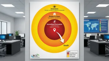
Layered Alert Zones with Differentiated Messaging
Building on dynamic boundaries, agencies create concentric zones around an incident to deliver different instructions for different risk levels:
- Immediate evacuation zone — "Leave now via Highway 101 South"
- Shelter-in-place zone — "Stay indoors, seal windows and doors"
- Awareness zone — "Monitor conditions, prepare to evacuate if conditions worsen"
This approach was effectively utilized in the 2020 CZU Lightning Complex fires, where San Mateo and Santa Cruz counties managed evacuation zones for over 70,000 residents using layered geographic targeting.
Predictive Geo-Targeting
Weather models, hazard modeling software, and infrastructure failure projections identify areas likely to be affected in the next hours or days, enabling proactive alerting. Preparatory alerts sent before impact allow for orderly evacuation and advance resource positioning rather than chaotic last-minute responses.
Practical applications include:
- Hazmat releases: Plume modeling tools generate dispersion footprints that are converted into alert polygons for immediate distribution
- Wildfire tracking: Perimeter data dynamically updates evacuation zones, though fire spread can outpace alerts if updates aren't frequent
- Flood forecasting: River gauge data triggers alerts to downstream communities before water arrives
Integration with FEMA-Compliant Incident Management Systems
Connecting geo-targeted alerting with incident management systems allows emergency managers to coordinate alerts with incident action plans, resource deployment, and multi-agency response efforts while maintaining NIMS compliance.
BCG's DisasterLAN became the first and only incident management system evaluated by FEMA's NIMS STEP program as fully compliant with NIMS and ICS principles as well as interoperability communications standards. This integration ensures geo-targeted alerts become part of a comprehensive incident management workflow spanning planning, coordination, communication, and recovery phases.
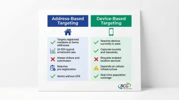
Address-Based vs. Device-Based Targeting
Address-based targeting sends alerts to people registered at addresses within the zone—useful for resident notifications but misses visitors, commuters, and people who haven't registered. Voluntary mass notification systems often plateau at 22-30% enrollment.
Device-based targeting sends to devices currently located in the zone via GPS/cell tower data—captures real-time populations including tourists and transients but depends on device capabilities and enabled location services.
Advanced strategies combine both approaches for comprehensive coverage, using address databases for pre-registered residents and device-based targeting through IPAWS Wireless Emergency Alerts to reach everyone physically present in the zone.
Key Factors That Affect Geo-Targeted Alerting Effectiveness
Several technical and operational factors determine whether geo-targeted alerts successfully reach at-risk populations.
Location Data Accuracy and Currency
Effectiveness depends on how current and precise recipient location information is. Outdated addresses, inaccurate GPS coordinates, or stale database records result in missed notifications or alerts to wrong populations. Emergency managers must regularly update address databases and verify location data quality.
Boundary Precision and Mapping Quality
Impact zones must be defined with sufficient accuracy using quality GIS data. Poorly drawn boundaries, incorrect coordinate systems, or misaligned map layers cause alerts to be sent to wrong areas or miss affected populations.
The NENA NG9-1-1 GIS Data Model standard mandates that GIS data used for emergency routing and location validation must meet strict accuracy requirements and be maintained in the WGS 84 coordinate system to ensure interoperability.
Using the wrong map projection can shift a polygon by hundreds of meters, potentially excluding the actual impact zone.
Technology Infrastructure and Device Capabilities
Alert delivery depends on several device and infrastructure requirements:
- Cellular connectivity and enabled location services
- Compatible operating systems and sufficient battery life
- Functional cell towers and power infrastructure
- Network capacity during high-demand events
During Hurricane Maria (2017), 95.2% of cell sites in Puerto Rico were out of service; six months later, 4% remained offline.
In contrast, NOAA Weather Radio infrastructure demonstrated 99% uptime during similar events, highlighting the importance of backup communication methods.
Opt-In Requirements vs. Location-Based Delivery
Opt-in systems (requiring app downloads or registration) typically reach only 15-30% of affected populations. Location-based systems like IPAWS Wireless Emergency Alerts reach all devices in an area but offer less targeting precision and limited message length (now expanded to 360 characters).
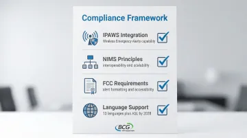
Compliance with IPAWS, NIMS, and Regulatory Standards
Effective geo-targeted alerting requires compliance with multiple standards:
- Integration with federal systems (IPAWS for Wireless Emergency Alerts)
- NIMS principles for interoperability and scalability
- FCC requirements for alert formatting and accessibility
- Support for 13 languages plus American Sign Language by 2028
Common Issues and Misconceptions
Misconception: Geo-Targeting Is Always GPS-Based
Many assume all geo-targeted alerts use real-time GPS tracking, but systems often rely on registered addresses, zip codes, or cell tower sectors. Each method has different accuracy levels and privacy implications.
Cell broadcast technology used in WEA doesn't track individual user locations—it broadcasts messages from towers covering the target area.
Confusion: Geo-Fencing vs. Geo-Targeting
These two location-based technologies serve different purposes, though emergency managers often use the terms interchangeably.
Geo-fencing triggers automated actions when devices enter or exit predefined areas (commonly used in marketing and asset tracking). Geo-targeting in crisis management filters alert recipients based on location within defined emergency zones. They represent different technical approaches with distinct crisis management applications.
Expectation: 100% Coverage Is Achievable
Emergency managers sometimes expect geo-targeted systems to reach every person in an impact zone, but coverage is limited by device ownership, cellular connectivity, opt-in rates, and infrastructure damage during disasters. Approximately 22% of U.S. census blocks lack 4G LTE coverage, making comprehensive mobile alerting impossible in many rural areas.
Oversimplification: Drawing a Boundary Is Sufficient
Effective geo-targeting requires understanding coordinate systems, map projections, data layers, and the relationship between displayed boundaries and actual alert delivery mechanisms.
Visual maps and technical implementation don't always align—what appears correct on screen may not translate to accurate alert distribution.
When Geo-Targeting May Not Be Appropriate
While geo-targeted alerts excel in many scenarios, certain situations call for different approaches. Understanding these limitations helps emergency managers choose the most effective notification strategy.
Organization-Wide Alerts Are More Effective
Internal corporate emergencies—data breach, IT outage, policy changes—typically require notifying all employees regardless of location. Geo-targeting adds unnecessary complexity when the entire organization is the audience.
Infrastructure Constraints Reduce Effectiveness
Rural areas with sparse cellular infrastructure present unique challenges. Populations with limited device ownership or without mobile phones (elderly, low-income communities) may not receive geo-targeted alerts reliably.
Traditional methods like sirens, door-to-door notification, and local media often work better in these environments.
Administrative Boundaries Work Better
For events aligned with jurisdictional boundaries—city-wide curfews, county evacuation orders, state emergency declarations—using administrative boundaries (entire city, county, state) is simpler and more appropriate than drawing custom geographic zones.
Signals of Inappropriate Use
Geo-targeting may not be the right choice when:
- Emergency managers default to location-based filtering without considering if it adds value
- The technology creates delays during time-critical situations
- Defining precise boundaries takes longer than the benefit justifies
- Simpler broadcast methods would reach the target audience more reliably
Conclusion
Geo-targeted crisis alerting uses location technologies to send emergency notifications only to affected populations within defined geographic boundaries. This approach reduces alert fatigue and optimizes crisis response.
Understanding the technical process, location data requirements, and integration with incident management systems matters for emergency managers who need reliable, compliant, and effective alerting capabilities during high-stakes crisis events.
Effective implementation requires:
- Choosing appropriate targeting strategies for each incident type
- Maintaining accurate location data across all systems
- Integrating with FEMA-compliant incident management platforms
- Knowing when organization-wide alerts serve better than targeted ones
The most effective emergency managers balance precision with practicality. They use geo-targeting when it adds genuine value while maintaining backup communication methods for when technology fails.
Frequently Asked Questions
Which tool is best for crisis management?
The best tool depends on organizational needs. FEMA-compliant systems like BCG's DisasterLAN (the only system fully evaluated by FEMA's NIMS STEP program) integrated with mass notification platforms provide comprehensive geo-targeted alerting and regulatory compliance.
How does geo-targeting work in emergency alerts?
Geo-targeting uses location technologies like GPS, cell tower data, or registered addresses to identify individuals within a defined emergency zone, then sends alerts only to those recipients through multiple channels.
What's the difference between geo-fencing and geo-targeting in crisis alerts?
Geo-fencing triggers automated actions when devices cross predefined boundaries (often used in marketing), while geo-targeting filters alert recipients based on their location within dynamically defined emergency zones—crisis management uses geo-targeting to send relevant alerts, not geo-fencing to trigger actions.
Can geo-targeted alerts work without cell phone GPS?
Geo-targeted systems can use registered addresses, zip codes, cell tower sectors, or IP geolocation instead of GPS, though each method has different accuracy levels—address-based targeting works for registered residents even without GPS-enabled devices.
How accurate are geo-targeted emergency notifications?
Accuracy depends on the location technology used: GPS-based targeting can be accurate to within 10-50 meters, cell tower triangulation to 100-500 meters, and zip code/administrative boundaries to entire neighborhoods—emergency managers must choose appropriate precision levels for each incident type.
What are the limitations of geo-targeted crisis alerts?
Geo-targeted alerts require cellular or internet connectivity, which fails when infrastructure is damaged. They also depend on device ownership and enabled location services, may miss visitors using address-based databases, and require accurate boundary definitions for evolving incidents.