Introduction
First responders now face incidents of increasing complexity, from multi-agency active shooter scenarios to coordinated natural disaster responses spanning multiple jurisdictions. According to the National EMS Database, 43 million EMS activations occurred in a single year. That volume generates massive amounts of operational data that legacy logging systems cannot handle.
Emergency analytics software transforms this flood of information into actionable intelligence. Modern platforms go beyond basic incident logging to deliver:
- Predictive capabilities that forecast resource needs before incidents escalate
- Real-time performance metrics showing response times and unit availability
- Pattern analysis revealing trends across weeks, months, and years
- Resource optimization tools that reduce response times and improve outcomes
With the global incident and emergency management market projected to exceed $200 billion by 2030, data-driven decision-making has become essential for competitive agencies.
This guide examines the top five emergency analytics software solutions specifically designed for first responders, including evaluation criteria, key features, and how to select the right platform for your agency's operational needs.
Key Takeaways
- Analytics platforms transform incident data into actionable intelligence for faster, better-coordinated response
- Top solutions pair NIMS/ICS compliance with predictive analytics, dashboards, and seamless integration
- Prioritize visualization clarity, high-stress usability, and scalability as incidents grow in complexity
- Best platforms enable real-time decisions and post-incident analysis for continuous improvement
Overview of Emergency Analytics Software for First Responders
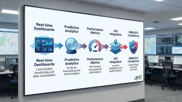
First responders face a critical challenge: making split-second decisions with incomplete information during high-pressure emergencies. Emergency analytics software transforms how agencies handle this challenge by collecting, analyzing, and visualizing incident data to support real-time decision-making and performance improvement.
These platforms incorporate predictive analytics, trend identification, and resource optimization algorithms—capabilities that extend well beyond simple incident logging.
How Analytics Platforms Differ from Basic Incident Management
Traditional incident management tools focus primarily on documenting what happened after the fact. Modern analytics-enabled platforms use machine learning and IoT sensor integration to enable real-time data collection and predictive modeling.
This shift allows agencies to move from reactive emergency management to proactive preparedness. Historical data and risk factors help forecast potential emergencies and optimize resource positioning before incidents occur.
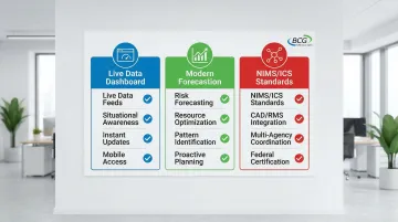
Key Capabilities That Define Analytics-Enabled Platforms
- Real-time situational awareness dashboards that aggregate data from multiple sources
- Predictive analytics that identify high-risk regions and optimal resource deployment
- Performance metrics tracking for response times, resource utilization, and operational efficiency
- Integration with GIS systems for spatial analysis and mapping
- Compliance with NIMS and ICS standards for seamless multi-agency coordination
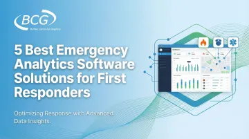
Top 5 Best Emergency Analytics Software Solutions for First Responders
We selected these five platforms based on their analytics capabilities, federal compliance standards, ease of deployment, integration features, and documented success with first responder agencies across the United States.
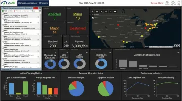
Buffalo Computer Graphics (BCG) DisasterLAN
BCG brings 43 years of emergency management software expertise to the table. DisasterLAN (DLAN) earned recognition as the first and only incident management system evaluated by FEMA's NIMS STEP program as fully compliant with NIMS and ICS principles.
DLAN's key differentiators include:
- Template-guided Incident Action Plans aligned with FEMA guidelines
- Comprehensive analytics dashboard for tracking response metrics
- Bandwidth-based licensing offering cost flexibility vs. per-seat pricing
- 300+ deployments across U.S. agencies demonstrating proven performance
| Category | Details |
|---|---|
| Key Analytics Features | Real-time incident tracking with customizable dashboards, performance metrics for response times and resource utilization, post-incident analysis tools for continuous improvement, integration with GIS systems for spatial analytics |
| Compliance & Standards | FEMA NIMS STEP certified (first and only), ISO/IEC 27001:2013 certified for data security, full NIMS and ICS compliance ensuring interoperability across agencies, template-guided workflows aligned with federal emergency management standards |
| Deployment & Support | Flexible cloud or on-premise deployment options, 300+ deployments across U.S. agencies, in-house U.S.-based development and technical support team, modular design that scales with organizational needs and budget constraints |
Why DLAN Excels: The FEMA NIMS STEP certification isn't just a credential—it represents the only incident management platform independently verified to meet federal interoperability standards. This ensures seamless coordination across local, state, and federal response teams during complex multi-agency incidents.
Juvare WebEOC
Juvare WebEOC has established itself as a widely adopted web-based crisis information management system for government agencies and emergency management organizations. The platform creates a common operating picture during incidents through situation reporting, resource tracking across multiple jurisdictions, and centralized dashboards that aggregate data from various sources.
WebEOC's recent integration of the Juvare AI Assistant (JAI) adds predictive insights and automated data processing capabilities that streamline decision-making during critical events.
| Category | Details |
|---|---|
| Key Analytics Features | Situational awareness dashboards with real-time data feeds and GIS mapping, AI-powered predictive insights through Juvare Analyze add-on, resource tracking for assets and personnel management, automated data processing to reduce manual entry burden |
| Compliance & Standards | Built to support NIMS-aligned workflows for cross-jurisdictional coordination, facilitates compliance with federal emergency management standards, interoperability features for multi-agency response |
| Deployment & Support | Cloud-native infrastructure ensuring high availability and scalability, proven track record across government and utility sectors, comprehensive training and implementation support |
Real-World Impact: Harnett County Emergency Services embedded Juvare AI into WebEOC to optimize operations and save resources, demonstrating measurable improvements in response coordination.
ESRI ArcGIS Emergency Management
ESRI's solution leverages industry-leading GIS technology to provide powerful geospatial analytics, mapping, and visualization capabilities for emergency operations. ArcGIS Emergency Management is particularly strong in spatial analysis, damage assessment, field data collection via mobile apps, and creating public-facing maps for community information sharing.
The platform's ArcGIS Velocity component allows real-time ingestion of data from IoT devices and sensors, enabling agencies to monitor rapidly changing conditions and make informed decisions based on current field intelligence.
| Category | Details |
|---|---|
| Key Analytics Features | Real-time mapping with data overlays from multiple sources, spatial analysis for resource deployment optimization, damage assessment analytics with mobile field data collection, integration with drone and IoT sensor data for situational intelligence |
| Compliance & Standards | Supports shared situational awareness across response teams and the public, integrates diverse data types for comprehensive emergency management, interoperability with other emergency management systems |
| Deployment & Support | SaaS deployment through ArcGIS Online, ArcGIS Instant Apps for rapid map portfolio deployment, mobile tools for field operations, requires GIS expertise for optimal implementation |
Proven Results: Oregon's Department of Emergency Management reduced map update times from 8-12 hours to near real-time using ArcGIS Instant Apps, dramatically improving decision-making speed during active wildfire incidents.
ESO Emergency Management Suite
ESO specializes in comprehensive data software for EMS, fire departments, and hospitals, offering integrated emergency management capabilities with strong emphasis on data analytics and performance metrics. The platform's strength lies in its electronic health records integration, data-driven insights for identifying response trends, and analytics tools that help agencies measure and improve operational performance.
ESO's Analytics module offers over 80 prebuilt reports and customizable dashboards to monitor both clinical and operational metrics, allowing agencies to drill down by quarter, month, day, or hour to identify trends and improve treatment decisions.
| Category | Details |
|---|---|
| Key Analytics Features | 80+ prebuilt performance reports and customizable dashboards, response time analysis and resource utilization metrics, trend identification tools for operational improvement, community health analytics for proactive emergency planning, health data exchange integration tracking patient outcomes from first contact to discharge |
| Compliance & Standards | Automated NEMSIS 3 compliance for EMS data reporting, NFIRS compliance for fire services, handles updates to federal reporting standards automatically, reduces compliance burden on agencies |
| Deployment & Support | Cloud-based platform with seamless integration to CAD, EHR, and billing systems, automated compliance reporting eliminates manual data entry errors, comprehensive implementation and training support |
Implementation Success: Iona-McGregor Fire District eliminated NFIRS reporting errors and saved significant time previously spent on manual compliance checks after implementing ESO's automated reporting capabilities.
D4H Incident Management
D4H offers a cloud-based platform designed specifically for emergency services, with focus on real-time incident logging, resource management, and operational analytics that improve coordination during critical events. The platform is known for its user-friendly interface optimized for high-stress situations, mobile accessibility for field operations, and reporting tools that provide insights into response performance.
D4H's customizable incident dashboards allow users to create a common operating picture with status boards, maps, and logs tailored to their specific operational needs.
| Category | Details |
|---|---|
| Key Analytics Features | Real-time incident dashboards with customizable status boards, response time tracking and task completion metrics, resource allocation analytics for equipment and personnel, customizable reports for performance evaluation, map pin color-coding for rapid damage assessments |
| Compliance & Standards | ISO/IEC 27001:2022 certification for information security management, database encryption at rest for data protection, supports emergency management coordination workflows |
| Deployment & Support | 100% cloud-based service hosted on Amazon Web Services (AWS), mobile-first design for field operations, staff can submit situation reports directly from mobile devices, rapid implementation timeline |
Field-Tested Performance: Monmouth County OEM uses D4H Equipment Management to maintain real-time supply visibility, which the coordinator described as a "lifesaver" for maintenance and time management during emergency operations.
How We Chose the Best Emergency Analytics Software
Our evaluation methodology focused on four critical dimensions that directly impact first responder effectiveness during emergency operations.
Analytics Depth Over Feature Lists
We prioritized platforms that provide genuine predictive capabilities and performance metrics, not just incident logging with basic reporting.
According to a DHS focus group study, "Capability" and "Usability" ranked as the most critical evaluation criteria, with GIS handling, accountability tracking, and information sharing emerging as top priorities.
NIMS/ICS Compliance for Interoperability
Federal compliance isn't optional—it's mandatory for jurisdictions receiving federal preparedness grants.
NIMS adoption is required at all government levels, providing the shared vocabulary and operational systems that enable diverse agencies to work together effectively during joint responses.
Integration Capabilities
The DHS study revealed that during incidents, organizations often use multiple disconnected solutions, highlighting integration failures. We evaluated how well each platform connects with existing CAD, RMS, and GIS systems to create seamless workflows.
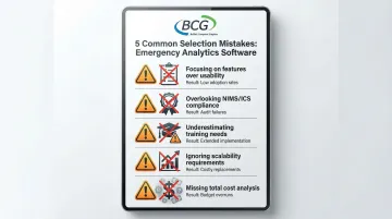
Common Selection Mistakes Agencies Make
Understanding these evaluation criteria helps agencies avoid common pitfalls during the selection process:
- Focusing solely on feature checklists rather than analytics depth and usability during high-stress situations
- Overlooking NIMS/ICS compliance requirements that affect multi-agency interoperability
- Underestimating training needs and implementation complexity, particularly for GIS-heavy platforms
- Failing to consider scalability as incident complexity and data volumes grow over time
- Ignoring total cost of ownership beyond initial licensing fees
Conclusion
The right emergency analytics software should align with your agency's specific operational needs, existing technology infrastructure, and long-term strategic goals—not simply the most feature-rich or well-known brand name. With the incident management market growing at over 5% annually, agencies have more choices than ever, making careful evaluation essential.
Key Evaluation Priorities
- Analytics capabilities: Prioritize platforms supporting both real-time decision-making and post-incident learning, with predictive insights that shift agencies from reactive response to proactive preparedness
- NIMS/ICS compliance: Verify certification for seamless multi-agency coordination, as interoperability ranks among the most critical capabilities during complex incidents
- Total cost of ownership: Calculate implementation, training, and ongoing support costs beyond initial licensing fees, including deployment flexibility and whether licensing models align with your budget
These priorities help narrow your selection to mature, analytics-enabled solutions built for the demands of emergency response.
Platforms like BCG's DisasterLAN combine FEMA NIMS STEP certification, proven performance across 300+ deployments, and flexible cloud or on-premise deployment options. With 43 years of experience and in-house U.S.-based development and support, BCG provides the stability and technical expertise that help first responder agencies make data-driven decisions when seconds matter.
Frequently Asked Questions
What is predictive analytics for disaster management?
Predictive analytics uses historical incident data, weather patterns, and risk factors to forecast potential emergencies and optimal resource positioning. This helps agencies identify high-risk regions before disasters strike, enabling proactive preparedness and timely evacuations.
What features should I look for in emergency analytics software for first responders?
Key features include real-time data visualization, performance metrics tracking (response times, resource utilization), NIMS/ICS compliance, CAD/RMS integration, and mobile accessibility. Look for predictive capabilities and customizable reporting that support both active incident management and post-incident analysis.
What's the difference between NIMS and ICS?
NIMS (National Incident Management System) is the comprehensive national framework guiding how all levels of government, NGOs, and private sector organizations manage incidents together. ICS (Incident Command System) is the standardized organizational structure within NIMS that defines specific roles, responsibilities, and command hierarchy during emergency response.
What is EOC software?
EOC (Emergency Operations Center) software supports coordination and decision-making by creating a common operating picture, tracking resources, and delivering situational awareness for multi-agency response. These platforms manage information collection, analysis, sharing, and resource allocation during emergencies.
How do emergency analytics software improve response times?
These platforms improve response times by providing real-time resource visibility to optimize dispatch decisions, identifying response bottlenecks through performance metrics, and using historical data to pre-position resources in high-risk areas. Systems like ArcGIS have reduced information lag from hours to minutes, enabling faster, data-informed decisions during active incidents.
Is emergency analytics software compliant with NIMS and ICS standards?
Compliance varies by platform. Agencies should verify NIMS/ICS alignment to ensure interoperability and grant eligibility. BCG's DisasterLAN holds FEMA NIMS STEP certification as the first and only independently verified compliant platform, while other solutions may require customization for full compliance.